FANGS - Fire Applications with Next-Generation Satellites
Contents
FANGS - Fire Applications with Next-Generation Satellites
FANGS - Fire Applications with Next-Generation Satellites features Python-based training support material and application cases on fire detection and monitoring of the fire life-cycle. The developed training support material makes use of proxy and simulated data, including data from precursor instruments of the Meteosat Third Generation (MTG) and EUMETSAT Polar System - Second Generation (EPS-SG) satellite missions. The EPS-SG satellite mission comprises the upcoming Metop Second Generation (Metop-SG) satellites, Metop-S and Metop-I.
The course is based on Jupyter notebooks, which allow for a high-level of interactive learning, as it makes code, instructions and visualisations available in the same location.
Executable notebooks are available on a dedicated Jupyterhub-based course platform:
Access the course notebooks on the Jupyterhub-based course platform
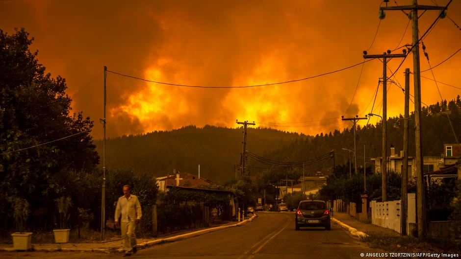
Fig. 1 Wildfires on the island of Evia, Greece in August 2021 (Source: AFP/Getty Images)
Upcoming instruments on MTG and EPS-SG
This course features the following upcoming MTG instruments:
Flexible Combined ImagerSentinel-4 Ultraviolet Visible Near-infrared (UVN)spectrometer
This course features the following upcoming EPS-SG & Metop-SG instruments:
Infrared Atmospheric Sounding Interferometer - New Generation (IASI-NG)METimageradiometerSentinel-5 Ultraviolet Near-infrared Shortwave (UVNS)spectrometer
And the following complementary, proxy or associated datasets:
Sentinel-2 MultiSpectral InstrumentLevel 2A dataSatellite Application Facility on Land Surface Analysis (LSA SAF)dataCopernicus Emergency Management Service (CEMS) Global ECMWF Fire Forecast (GEFF)dataCopernicus Atmosphere Monitoring Service (CAMS) Global Atmospheric ForecastsCAMS Global Fire Assimilation System (GFAS)dataModerate Resolution Imaging Spectroradiometer (MODIS)data by NASAGeostationary Operational Environmental Satellite-R Series (GOES-R)data by NASA
Training support material
The training support material follows a modular approach and features multi-part application case studies that focus on different parts of the fire life cycle. Each case study module consists of two to six narrative notebooks describing the event and how the upcoming MTG and EPS-SG satellites will improve the capabilities to monitor the full fire life cycle, together with figures comprising maps and animations of satellite data products for each event. The narrative notebooks highlight different parts of the fire life cycle - from pre-fire risk, active burning and smoke transport to assessing post-fire impacts. Each figure in the narrative notebooks is linked to a workflow notebook showing how the proxy data was processed to showcase the upcoming data from MTG and EPS-SG (Metop-SG).
Note
Throughout the course, general functions to load, re-shape, process and visualize the datasets are defined. These functions are re-used when applicable. The functions notebook gives you an overview of all the functions defined and used for the course.
If a notebook makes use of these functions, they are loaded as helper functions at the beginning of the notebook. With ?function_name, you can load the function’s docstring to see what it does and which keyword arguments the function requires. See the example to load the docstring of the function visualize_pcolormesh
%run ./functions.ipynb
?visualize_pcolormesh
As many Python library packages use American English, the functions also use American English for consistency. Hence, you will note that spellings for “color” and “visualize” are used instead of their British English equivalents.
Learning outcomes
The course is designed for intermediate users, who have basic Python knowledge, basic earth observation knowledge and basic understanding of the fire life cycle.
After the course, you should:
have learned about upcoming datasets and instruments from MTG and EPS-SG,
been introduced to the useful Python packages to handle, process and visualise large volumes of earth observation data
gained an understanding about how upcoming datasets will enable new capabilities in monitoring different aspects of the fire life cycle
Contact
If you have questions or feedback about this module, please contact the EUMETSAT Training Team.